
K4EQM QSO Contact Map: Turn Your Ham Radio Logs Into Interactive Maps
K4EQM QSO Contact Map turns ham radio logs into interactive maps for WordPress. Whether you are posting a contest recap, Field Day log, POTA activation, SOTA activation, or general QSO summary, the plugin helps show where your contacts went.
Ham radio is full of great moments: the surprise DX contact, the clean Field Day exchange, the late-night contest run, the POTA pileup, or the local QSO that turns into a new friendship. Most of those contacts eventually end up in a log file. That log is useful, but it does not always tell the story very well.
That is why I built K4EQM QSO Contact Map, a WordPress plugin that turns amateur radio contact logs into interactive maps.
The goal is simple: upload a CSV file of QSOs, place your station on the map, and create a clean visual recap that you can share on your website.
What Is K4EQM QSO Contact Map?
K4EQM QSO Contact Map is a WordPress plugin for amateur radio operators who want to display their QSOs on a map inside a WordPress-based website.
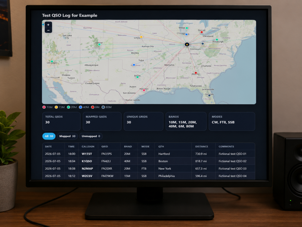
Instead of only showing a plain log table, the plugin creates a visual map with your station in the center and your contacts plotted around it. When the log includes location data, such as latitude and longitude or Maidenhead grid squares, the plugin can map each contact and draw lines from your station to the stations you worked.
It also creates a clean QSO summary with useful information such as total QSOs, mapped QSOs, unique grids, bands worked, modes used, and your furthest QSO.
A contact table can also appear below the map. That way, visitors can view the actual log details along with the visual contact map.
What Is This Ham Radio Mapping Plugin For?
This plugin is designed for hams who want to share their operating activity in a more interesting way.
A normal contact log is useful. However, a map makes the activity much easier to understand at a glance. You can quickly see where your signal reached, what areas you worked, and how different bands performed.
You can use this plugin for many types of amateur radio activity, including:
- Contest recaps
- Field Day logs
- POTA and SOTA activations
- Special event stations
- Club websites
- Personal ham radio blogs
This can be especially useful for events like ARRL Field Day, Parks on the Air, and Summits on the Air.
For example, after a contest or Field Day operation, you can upload your log and publish a visual recap. Likewise, after a POTA or SOTA activation, you can show where your contacts came from and how far your signal traveled.
How K4EQM QSO Contact Map Works
The workflow is simple.
- Export your contacts from your logging software as a CSV file.
- Open the QSO Maps section inside WordPress.
- Upload the CSV file.
- Enter your station location.
- Copy the generated shortcode.
- Paste the shortcode into a page or post.
After the upload, the plugin reads the log, looks for common fields, and creates a map from the contact data.
The plugin can detect common CSV columns such as callsign, date, time, band, frequency, mode, grid square, latitude, longitude, QTH, state or section, country, and comments.
For a QSO to appear on the map, the contact needs some type of location information. The best options are either latitude and longitude or a Maidenhead grid square.
If a contact does not include location data, it can still appear in the table. However, it cannot be plotted on the map unless a location is available.
Using Your Own Station Location
When creating a map, you can enter your own station latitude and longitude. There is also a Use My Location button that asks your browser for your current position and fills in the fields automatically.
This is useful for portable operations, activations, club events, or field setups where your station location changes.
Once your location is set, the plugin can calculate distances and draw contact lines from your station to mapped QSOs.
Displaying a K4EQM QSO Contact Map on a Page or Post
After uploading a CSV file, the plugin creates a shortcode. You can copy that shortcode and paste it into any WordPress page or post.
[qso_contact_map id="96"]When the page loads, WordPress replaces that shortcode with your QSO map, summary cards, and contact table.
This makes it easy to create a recap page for a contest, Field Day event, POTA activation, SOTA activation, or general ham radio log.
Front-End QSO Map Features
The public map is built to be useful for visitors, not just the site owner.
Visitors can view the interactive map, zoom in, pan around, and look at the contact spread. On mobile and tablet devices, the map supports touch interaction, including pinch-to-zoom.
The table can also include filters for all QSOs, mapped QSOs, and unmapped QSOs.
In addition, a front-end toggle lets visitors show or hide unmapped contacts in the table. This keeps the public page clean while still letting readers inspect the full log when needed.
Global Display Settings
Inside WordPress, the plugin includes settings for how maps and tables should appear across the site.
Current settings include dark mode styling, table filter buttons, public table column controls, and an optional public credit link.
The public credit link is off by default. However, site owners can turn it on if they want to support the project and point visitors back to K4EQM.
Why I Built This WordPress QSO Map Plugin
I built K4EQM QSO Contact Map because ham radio contacts are more than rows in a logbook.
A log tells you who you worked. A map helps tell the story of where your signal went.
For events like Field Day, POTA, SOTA, and contests, that visual story matters. It helps other hams understand the operation. It also makes amateur radio easier to explain to people who are new to the hobby.
A map can show in a few seconds what a table might take several minutes to understand.
What Kind of CSV File Should I Use?
The plugin works best with CSV files that include location data.
A good CSV might include columns like this:
date,time,callsign,band,mode,grid,qthAnother good option is a file with latitude and longitude:
date,time,callsign,band,mode,latitude,longitude,qthIf your logging software exports Maidenhead grid squares, that is usually enough to map the contact.
If your CSV only includes callsigns with no location fields, the plugin can still list the contacts. However, it will not be able to map them unless location data is added.
Final Thoughts
K4EQM QSO Contact Map gives amateur radio operators a simple way to turn CSV logs into interactive WordPress maps.
Whether you are recapping a contest, sharing a Field Day log, documenting a POTA activation, or building out your own ham radio website, this plugin helps show where your signal went.
If you want to make your ham radio logs more visual, more useful, and more shareable, this plugin was built for exactly that.
You can also visit the K4EQM home page for more ham radio projects, posts, and updates.